A hyperactive season is not out of the question, suggests Moody’s, in its 2024 Northern Hemisphere Tropical Cyclone Outlook report.

Moody’s RMS Event Response has issued an executive summary of its 2024 Northern Hemisphere Tropical Cyclone Outlook report for the 2024 North Atlantic hurricane season already underway.
This executive summary includes a review of North Atlantic and Western North Pacific seasonal forecasts for 2024 and a look at the key oceanic and meteorological drivers of those forecasts.
The rating agency emphasised that forecasters think a busy season is upon us.
“According to the latest seasonal tropical cyclone forecasts issued by numerous meteorological agencies and groups, there is a strong consensus that the 2024 North Atlantic hurricane season is expected to be above average, with some forecasts suggesting a hyperactive season is not out of the question,” the report said.
Moody’s observed that last year only one significant storm made US landfall.
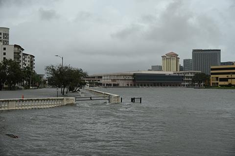
Hurricane Idalia (aftermath pictured) became the first major hurricane to make landfall in Florida’s Big Bend region and to impact the state’s northwestern coastal area since the 1896 Cedar Keys Hurricane.
“Idalia served as an important reminder of the devastating impacts that natural catastrophes can have, even in previously largely unaffected areas. It brought destructive hurricane-force winds and a catastrophic storm surge to much of northwestern Florida.
“Idalia’s strongest winds were limited to a small area near landfall in a sparsely populated section of the Florida coastline, owing to the storm’s compact structure, which limited its market impact,” Moody’s noted.
This year’s forecast reflects the combined influence of several big seasonal oceanic and atmospheric factors that typically influence intraseasonal hurricane activity in the North Atlantic, primarily North Atlantic sea surface temperatures and the El Niño-Southern Oscillation (ENSO).
“Sea surface temperatures in the North Atlantic are at or near record warm levels across most of the tropical and eastern portions of the subtropical North Atlantic, and they are expected to remain at or near record levels throughout the coming months. Warmer sea surface temperatures typically result in a more active North Atlantic hurricane season owing to the increased energy available for cyclogenesis and intensification,” Moody’s said.
ENSO is expected to transition into a La Niña phase by the fourth quarter, perhaps even in time for the peak months of the hurricane season of August, September and October.
“La Niña conditions in the equatorial Pacific typically result in a more active North Atlantic hurricane season due to decreases in vertical wind shear and increased instability across the basin,” the report said.
“Even if cool-neutral ENSO conditions prevail, an active hurricane season could still be possible given the hurricane-conducive oceanic conditions in the North Atlantic. Last year’s hurricane season was characterized by a tug-of-war,” Moody’s said.
In 2023, ENSO was in an El Niño phase, which marginally hindered activity, the ratings firm said, while record warm sea surface temperatures in the North Atlantic promoted activity.
“There is expected to be no such tug-of-war in 2024, with the warmer-than-average North Atlantic sea surface temperatures and ENSO’s transition to a La Niña phase both expected to promote hurricane activity in the basin,” Moody’s said.
“While oceanic and atmospheric conditions are primed and look set to result in an active year, we cannot be as certain of the influence of several other sub-seasonal factors, which can modulate tropical cyclone activity on a weekly or monthly basis and are difficult to forecast at seasonal timescales. Such factors can include the North Atlantic Oscillation (NAO), the Saharan Air Layer (SAL), and the Madden-Julian Oscillation (MJO),” Moody’s added.


No comments yet